
Digital 3D Models + Orthorectified Images
Lonestar Lidar provides a full suite of high-fidelity data products tailored for Texas infrastructure, land development, and environmental management. Our integrated approach combines precision 3D Digital Modeling with High-Resolution Orthorectified Imagery to give you a complete, measurable view of your project site.
IMAGES
LiDAR 3D Digital LiDAR Models + Orthorectified Images
LiDAR 3D Digital Modeling + LiDAR 3D Digital
Digital Elevation Models (DEMs) + Digital Terrain Models (DTMs)
DIGITAL 3D MODELING + 3D MAPPING
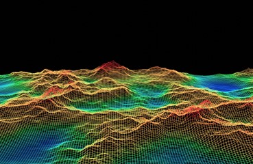
3D Digital Elevation Models (DEMs) from LiDAR Data Point Clouds
LIDAR DATA POINT CLOUDS
LiDAR Data Point Cloud - 1st Return, 2nd Return, 3rd Return, 4th Return
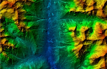
DIGITAL 3D MAPPING + 3D MODELING
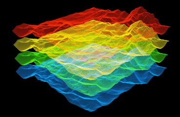
3D Digital Terrain Models (DTMs) from LiDAR Data Point Clouds
LiDAR 3D Digital Modeling
3D LiDAR modeling is the process of converting raw point clouds—millions of individual laser measurements—into highly accurate digital maps. Our sensors emit thousands of laser pulses per second, measuring the exact distance to every object in their path to create a dense, three-dimensional data set.
Multi-Return Data & Accuracy
A key advantage of LiDAR is its ability to record multiple returns from a single laser pulse. As the light travels, it reflects off various layers:
- First Returns: Capture the highest points, like tree canopies or building rooftops.
- Intermediate Returns: Capture mid-level vegetation and structures.
- Last Returns: Penetrate through gaps to reach the actual ground surface.
By combining these returns with multispectral imaging, we can produce 3D models with superior clarity and detail.
Industry-Standard Deliverables
We use this multi-layered data to generate three primary types of 3D models:
- Digital Terrain Models (DTM): A “bare earth” view with all vegetation and man-made structures removed.
- Digital Surface Models (DSM): Captures the natural and built environment, including tree heights and rooftops.
- Digital Elevation Models (DEM): Provides a precise representation of the earth’s surface for flood modeling and engineering.
LiDAR Hawaii Offers the Following 3D Digital Models:
-
Digital Terrain Models or DTMs.
-
Digital Surface Models or DSMs.
-
LiDAR Data Point Clouds: 1st Return, 2nd Return, 3rd Return, 4th Return.
-
Multi Spectral Images + Multi Spectral Imaging
-
Digital Elevation Models or DEMs + Texas Digital Elevation Model + Texas GIS DEM
LiDAR 3D Digital Models + Orthorectified Images
Georeferenced Orthoimages + High Accuracy Photo Mosaics
High Resolution Aerial Photographs + Aerial Drone Photos
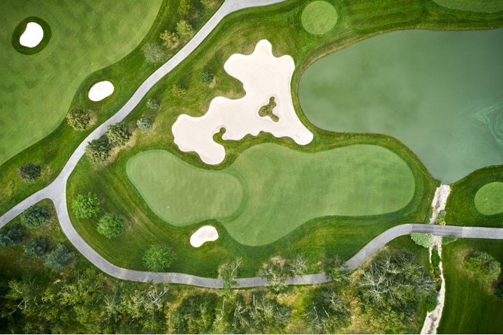
Georeferenced Orthorectified Images + High Resolution Photo Mosaics
High-Resolution Orthorectified Imagery
An orthoimage bridges the gap between a standard aerial photograph and a precise engineering map. While raw drone or helicopter photos contain distortions caused by camera tilt, sensor geometry, and terrain relief, our orthorectification process removes these variations. By applying a mathematical correction to every pixel, based on sensor calibration and digital elevation models, we produce a uniform-scale image with the geometric accuracy of a surveyed map.
Professional Verification & Ground-Truthing
Accuracy is not left to software alone. Our Licensed Professional Land Surveyor conducts rigorous ground-truthing on every project site. By verifying that digital calculations match physical monuments and control points found on the ground, we ensure that the imagery meets the strict tolerances required for Texas civil engineering and legal boundary work.
Precision Photo Mosaics & GIS Integration
For large-scale projects, we utilize advanced stitching software to create a seamless Digital Orthoimage Photo Mosaic. These mosaics are georeferenced to known ground positions, allowing them to function as an intelligent map overlay.
- Seamless Overlay: Mosaics are draped over LiDAR-derived digital models (DTM/DEM) to provide a “real-world” visual context to 3D elevation data.
- Measurement & Analysis: This integrated data allows for precise distance, area, and volumetric calculations directly within a GIS or CAD environment.
- Project Planning: Civil engineers, architects, and developers rely on these georeferenced overlays for site design, drainage analysis, and utility routing across the Texas landscape.
High Resolution Orthorectified Image Benefits Include the Ability to Use Orthoimages for the following:
-
Georeferenced orthoimages as a map layer in GIS applications.
-
Analyzing and measuring objects in the orthoimages.
-
Overlaying other data layers on top of the orthoimage for analyzing and measuring.
-
Displaying the orthoimage as a topographic map with elevations.
Geospatial Data Products
LoneStar provides a comprehensive suite of geospatial products, from georeferenced orthoimages and high-resolution aerial photography to detailed UAV-captured imagery.
Not sure which deliverables best fit your specific needs? Or do you need a hand integrating this data into your existing workflow? No problem, our team is here to help you navigate the technical side and determine the most efficient solution for your project requirements.
Please contact us directly to discuss your specific geospatial data product needs.
Learn more about LiDAR by clicking here.